
foto
How much is the sea level rising and why is it rising?
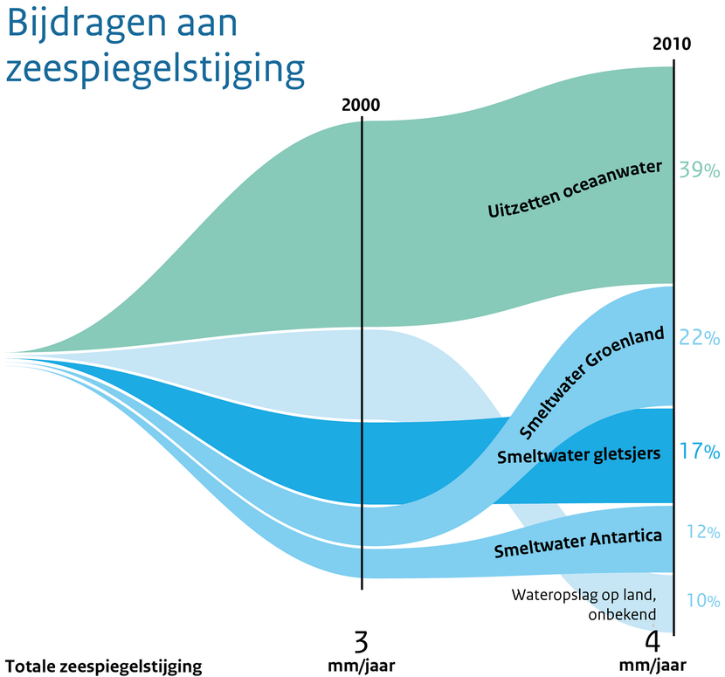
You hear a lot in the news about glaciers (land ice) melting. Due to climate change, the earth is warming up, glaciers are melting and seawater is getting warmer. The meltwater flows into the seas and the warmer seawater expands. This causes the sea level to rise. Since 2010, the rise has been even faster than before. The global sea level is rising by 4 to 5 millimetres per year.
Where is the sea level rising?
Melting sea ice (as on the North Pole) does not change the sea level because sea ice already floats. Globally, the sea level is rising faster than previously assumed. The North Sea is relatively small, so the accelerated rise has not yet been measured in the Netherlands. Many local effects play a greater role, such as changes in wind and sea currents. But here too we will start to notice the consequences.
Foto

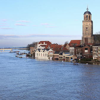
Floods in the Netherlands are a real danger
The Netherlands lies in a delta, which means that large parts of our country lie below sea level. Large rivers such as the Rhine and the Meuse flow through our country into the North Sea. Floods in the Netherlands originate not only from the sea, but also from rivers. An increase in peak discharges due to more precipitation upstream also increases the likelihood of flooding from rivers.
The soil in the western Netherlands is also subsiding as a result of natural processes and the drying out of peatlands. This subsidence is 4 to more than 5 millimetres per year.
Floods can come from anywhere. It comes from the sea or the major rivers and/or from inland waterways such as canals and lakes. A (peat)dike can subside, a dune can be swept away or the water can come over the dikes.
Flood map
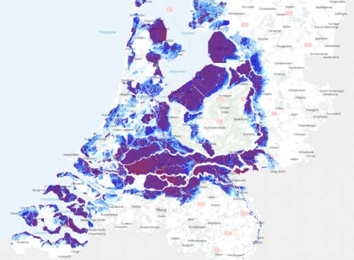
This map shows where and how deep the Netherlands will be flooded if the primary water defences break.
Dikes
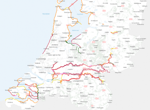
The map shows the dikes of the Netherlands with the various protection levels (in different colours).
Where will it stay dry?
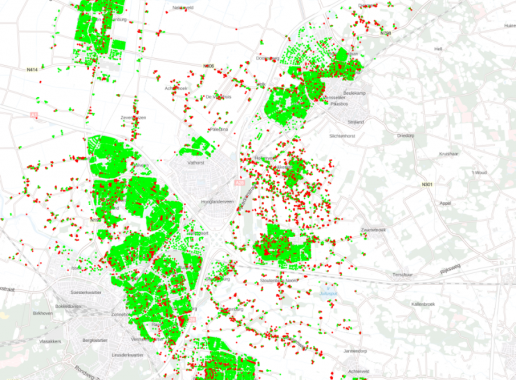
Which building has a dry floor where I can take shelter if there is a flooding threat?
foto
Rising sea levels and health
Floods can cause a lot of stress. Your home may be flooded, and cause damage and danger to your possessions. Flooded streets also create unsafe situations.
Floods can cause a power outage, with all its unpleasant consequences. You can no longer call for help. The heating system may stop working and you may become hypothermic. The freezer stops working, causing food to spoil.
Drinking water sources become contaminated because dirty water mixes with clean water. This can make it temporarily impossible to use clean drinking water. The government may then advise you to evacuate.
How do you prepare for a flood?
First of all, it is important to check whether your home is located in a place where there is a risk of flooding. You can see this on the map of the maximum water depth in the event of a flood.
- If your home is at risk of being partially submerged in the event of a flood, make sure you have an emergency kit. This could include bottled water, canned food, a torch and a first-aid kit;
- Check the dry floors map to see if your home has a dry floor in case of flooding;
- Collect addresses where you can go in case of an emergency;
- Check the routes to get there;
- Read more about how to prepare for a flood on the Risicokaart (risk map) or Overstroom ik? (Will I flood?).
Overstroming voorkomen
Alle overheden – Rijk, provincies, waterschappen, veiligheidsregio's en gemeenten – werken samen om een overstroming te voorkomen en de gevolgen ervan kleiner te maken. Waterkeringen (dijken, dammen, duinen, sluizen en gemalen) beschermen grote delen van Nederland tegen het water. Rijkswaterstaat en de waterschappen onderhouden en controleren deze waterkeringen. Dit staat opgeschreven in het Hoogwaterbeschermingsprogramma.
De waterstanden worden altijd bewaakt. Gemeenten informeren en waarschuwen de bevolking als problemen optreden. Samen met hulpdiensten oefenen overheden regelmatig wat ze moeten doen bij een (dreigende) overstroming.
De overheid wil Nederland nu en in de toekomst beschermen tegen hoogwater en wil zorgen voor voldoende zoetwater. Ook wil de overheid ons land zo inrichten dat het aangepast is aan een veranderd klimaat. Wat voor deze drie thema’s moet gebeuren staat in het Deltaprogramma. Hierbij is water de belangrijkste basis en moet water centraal staan bij ruimtelijke inrichting.
foto
Flood policy
All government entities - the central government, provinces, water boards, safety regions and municipalities - work together to prevent flooding and minimise the consequences. Water defences (dikes, dams, dunes, locks and pumping stations) protect large parts of the Netherlands against water. Rijkswaterstaat (the Directorate-General for Public Works and Water Management) and the water boards maintain and inspect these water defences. This is laid down in the Hoogwaterbeschermingsprogramma (High Water Protection Programme).
The water levels are constantly monitored. Municipalities inform and warn the population, should problems arise. Together with the emergency services, the authorities regularly practice what to do in the event of (imminent) flooding.
Protecting the Netherlands against flooding now and in the future The government wants to protect the Netherlands against high water and ensure there is sufficient fresh water. The government also wants to organise our country so that it is adapted to a changed climate. What needs to be done for these 3 themes is set out in the Delta Programme. Here, water is the most important foundation and must be central to spatial planning.
Interesting websites (in Dutch)


