Just think of the rugged Wadden area, the big skies, urban planning, architecture and nature. The beauty of the Netherlands is under pressure. After all, the Netherlands is one of the most densely populated areas in the world. Space is needed for living, working, nature, recreation and mobility.
If an area is being developed properly, all the various interest groups will be given a voice. More than before the provincial governments and municipalities have the freedom to decide how to structure their regions. All new spatial plans of the state, provincial governments and municipalities can be viewed at Ruimtelijkeplannen.nl.
Quality of life
Most people in the Netherlands live in close proximity to each other in towns and cities. Therefore it is difficult to maintain the quality of the environment. Problems can arise due to environmental influences, but also social safety may come under pressure. In order to maintain the quality of the living environment at a high level, the government is working on the restructuring of neighbourhoods and the reduction of air pollution and noise pollution in the living environment. It is also working on making the streets safer and on providing sufficient greenery.
Leefomgeving en gezondheid
De leefomgeving heeft invloed op de gezondheid van de mensen die er wonen. Aantrekkelijke en veilige fiets- en wandelroutes, parken en speelplekken maken het bijvoorbeeld leuker om te bewegen. En dat is goed voor de gezondheid. In de praktijk zijn er soms knelpunten. Denk bijvoorbeeld aan een aangewezen plek voor een speelterrein die nou nét langs een drukke weg ligt. Een goede afweging van de mogelijke effecten op de gezondheid is daarom belangrijk. Liefst in overleg met de mensen die er wonen. Dit kan bijvoorbeeld met de Leefplekmeter; wat vind jij eigenlijk van je leefplek?
Beoordelen gezondheidsgevolgen ruimtelijke plannen
Bij ruimtelijke plannen is het belangrijk om de mogelijke effecten op de gezondheid vooraf goed in kaart te brengen. Daar bestaan verschillende methoden voor, met elk hun voor- en nadelen. De keuze hangt af van het precieze doel van het in kaart brengen van de gezondheid. We bespreken er hier twee: het Milieugezondheidsrisico (MGR) en de Gezondheidseffectscreening (GES). Andere instrumenten vindt u op de website Gezonde Leefomgeving.
Milieugezondheidsrisico (MGR)
Het RIVM ontwikkelde de Milieugezondheidsrisicokaart. Doel was om de effecten van luchtvervuiling en omgevingsgeluid op de gezondheid bij elkaar opgeteld op de kaart te kunnen laten zien. Hoe groot zijn de effecten op de gezondheid? Dat hangt af van de ligging van steden, wegen, industrie en vliegvelden.
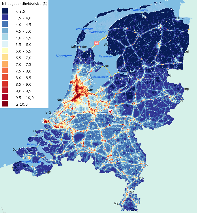
Beleidsmakers zoeken vaak plekken waar nog kan worden gebouwd zonder de gezondheid van omwonenden te verslechteren. Vaak stapelen risicofactoren op. Op plekken waar veel luchtvervuiling is, is ook de geluidsbelasting hoog. De MGR kan laten zien hoe nieuwe plannen uitpakken voor het hele gebied. Worden de lasten gelijk(er) verdeeld?
Gemiddeld is zo'n 5-6%* van alle ziekte en sterfte in Nederland toe te schrijven aan milieufactoren. Bekijk op de kaart of uw plek hoger of lager scoort. U kunt op de kaart vaak de steden en (snel)wegen herkennen. Daar is de opeenstapeling van geluid en luchtvervuiling het grootst. De uitkomsten zijn schattingen, bedoeld om verschillen van plek tot plek te laten zien.
* Dit percentage komt uit de Volksgezondheidtoekomstverkenning uit 2014. Een nieuwere schatting gaat uit van 4% in plaats van 5-6% (VTV). In de Volksgezondheid Toekomst Verkenning (VTV) brengt het RIVM elke vier jaar verslag uit over de ontwikkeling van de volksgezondheid in Nederland. Het RIVM past de kaart daarom in 2019 aan.
Gezondheidseffectscreening (GES)
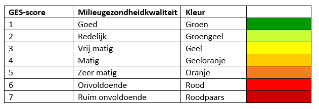
De gezondheidseffectscreening (GES) is een andere methode om gezondheid op de kaart te zetten. Deze neemt niet alleen lucht en geluid mee, maar ook (on)veiligheid, geur en stralingsbelasting. De provincies Noord-Brabant en Utrecht maken bijvoorbeeld GES-kaarten om te laten zien waarom zij bepaalde beleidsmaatregelen nemen. Ook GGD-en maken gebruik van deze methode. Verschillende kleuren op de kaart maken duidelijk hoe groot de nadelige gevolgen voor de gezondheid zijn (zie tabel). Groen is goed en rood is slecht. Bij rood voldoet de leefomgeving niet aan de wettelijke normen. De provincie Utrecht combineert de GES-kaart met de ligging van bijvoorbeeld scholen en verpleeghuizen. Daar komen/wonen namelijk mensen die (extra) gevoelig kunnen zijn voor gezondheidseffecten. Zo worden de knelpunten zichtbaar.
Gezondheidseffectscreening kaarten (provincie Noord-Brabant)
GES Geluid spoorwegen (Lden 2013)
GES Geluid vliegverkeer vergund (2014)
GES Geluid rijkswegen (Lden 2013)
GES Luchtkwaliteit fijnstof (pm10)
GES Luchtkwaliteit fijnstof (pm2,5)
GES Geur industrie (2015)
GES Geur veehouderij obv hinderpercentages (2013)
GES Luchtkwaliteit stikstofdioxide (NO2)
GES Geluid provinciale wegen (Lden 2013)
GES Geluid industrie
Gezondheidseffectscreening kaart (provincie Utrecht)
Effecten van milieu op gezondheid, provincie Utrecht 2018
Spatial Planning Act and the Environmental and Planning Act
The Spatial Planning Act is an important law in the context of spatial decision-making. The law describes the division of roles between the state, the provincial governments and the municipalities. The Spatial Planning Act is the instrument for distributing spatial needs such as living, working, recreation, mobility, water and nature on the basis of a coherent approach.
Other laws related to spatial planning are the Environmental Law (General Provisions) Act and the Transport Infrastructure (Planning Procedures) Act. The government is going to replace the WRO and various other laws with the Environmental and Planning Act. This law will make the taking of decisions on spatial projects faster and simpler.
Structural vision and zoning plans
The state, provincial governments and municipalities create structural visions for their own area. These include the global plans which the government has for a particular area. The National Policy Strategy for Infrastructure and Spatial Planning contains the state's plans on space and mobility in 2040. For example, in the Structural Vision the government describes which infrastructure projects they want to invest in during the coming years as well as how the existing infrastructure can be used more effectively. The plans give the provincial and municipal governments more room to manoeuvre in the field of spatial planning.
The municipalities' structural visions are implemented via changes to the zoning plan. A zoning plan is used to record the intended use and type of building in an area. For example, it stipulates whether a residential neighbourhood or industrial estate may be built and whether any high-rise or low-rise buildings are permitted.
When the Environment and Planning Act comes into force, structural visions and zoning plans are to be replaced by environmental visions and environmental plans.
What can citizens do?
Anyone who wants to build or make alterations needs a variety of permits. In order to make it easy for citizens and companies, the permits for building, living, monuments, space, nature and the environment have been combined into a single All-in-one Permit for Physical Aspects. You can apply for this permit digitally via The Online Environmental Desk.
What can professionals do?
There are all kinds of ways in which your living environment can be organised (more) healthily. If you need some inspiration, you should check the Healthy Living Environment Guide.
Read more about spatial area
- Landscape in the Netherlands
- The Livability Barometer
- m.e.r. commission methods
- Ruimtelijkeplannen.nl
- Environmental Desk
- Environmental and Planning Act portal
- HealthyDesignGuide
- Healthy Living Environment Guide
- Infrastructure strategy appraiser
- Healthy Living Portal
- Balance of the Living Environment
- Healthy Mobility
- Sustainable and Smart Mobility dashboard
- Healthy in…